Lenticular clouds, like this one over a mountain in Chile, can look like flying saucers. Bilderbuch/Design Pics Editorial/Universal Images Group via Getty Images
Curious Kids is a series for children of all ages. If you have a question you’d like an expert to answer, send it to curiouskidsus@theconversation.com.
“How are clouds’ shapes made?” – Amanda, age 5, Chile
I’m a meteorologist, and I’ve been fascinated by weather since I was 8 years old. I grew up in Minnesota, where the weather changes from wind-whipping blizzards in winter to severe thunderstorms – sometimes with tornadoes – in the summer. So, it’s not all that surprising that I’ve spent most of my life looking at clouds.
All clouds form as a result of saturation – that’s when the air contains so much water vapor that it begins producing liquid or ice.
Once you understand how certain clouds develop their shapes, you can learn to forecast the weather.
Cloud types show their general heights.
Australian Bureau of Meteorology
Cotton ball cumulus clouds
Clouds that look like cartoon cotton balls or cauliflower are made up of tiny liquid water droplets and are called cumulus clouds.
Often, these are fair-weather clouds that form when the Sun warms the ground and the warm air rises. You’ll often see them on humid summer days.
Cumulus clouds over Lander, Wyo.
Ross Lazear, CC BY-ND
However, if the air is particularly warm and humid, and the atmosphere above is much colder, cumulus clouds can rapidly grow vertically into cumulonimbus. When the edges of these clouds look especially crisp, it’s a sign that heavy rain or snow may be imminent.
Wispy cirrus are ice clouds
When cumulonimbus clouds grow high enough into the atmosphere, the temperature becomes cold enough for ice clouds, or cirrus, to form.
Clouds made up entirely of ice are usually more transparent. In some cases, you can see the Sun or Moon through them.
Cirrus clouds over the roof of Bard College in Annandale-on-Hudson, N.Y.
Ross Lazear, CC BY-ND
Cirrus clouds that forms atop a thunderstorm spread outward and can form anvil clouds. These clouds flatten on top as they reach the stratosphere, where the atmosphere begins to warm with height.
However, most cirrus clouds aren’t associated with storms at all. There are many ice clouds associated with tranquil weather that are simply regions of the atmosphere with more moisture but not precipitation.
Fog and stratus clouds
Clouds are a result of saturation, but saturated air can also exist at ground level. When this occurs, we call it fog.
In temperatures below freezing, fog can actually deposit ice onto objects at or near the ground, called rime ice.
Reading clouds, with the National Oceanic and Atmospheric Administration.
When clouds form thick layers, we add the word “stratus,” or “layer,” to the name. Stratus can occur just above the ground, or a bit higher up – we call it altostratus then. It can occur even higher and become cirrostratus, or a layer or ice clouds.
If there’s enough moisture and lift, stratus clouds can create rain or snow. These are nimbostratus.
How mountains can create their own clouds
There are a number of other unique and beautiful cloud types that can form as air rises over mountain slopes and other topography.
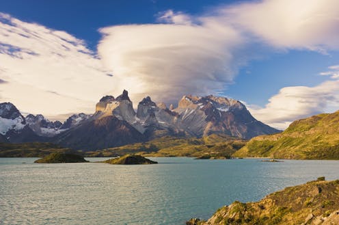
Lenticular clouds, for example, can look like flying saucers hovering just above, or near, mountaintops. Lenticular clouds can actually form far from mountains, as wind over a mountain range creates an effect like ripples in a pond.
A banner cloud appears to stream out from the Matterhorn, in the Alps on the border between Italy and Switzerland.
Zacharie Grossen via Wikimedia, CC BY
Rarer are banner clouds, which form from horizontally spinning air on one side of a mountain.
Wind plays a big role
You might have looked up at the sky and noticed one layer of clouds moving in a different direction from another. Clouds move along with the wind, so what you’re seeing is the wind changing direction with height.
Cirrus clouds at the level of the jet stream – often about 6 miles (10 kilometers), above the ground – can sometimes move at over 200 miles per hour (320 kilometers per hour). But because they are so high up, it’s often hard to tell how fast they are moving.
Ross Lazear does not work for, consult, own shares in or receive funding from any company or organization that would benefit from this article, and has disclosed no relevant affiliations beyond their academic appointment.