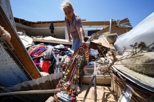
Juana Landeros and her husband and 9-year-old son survived a deadly tornado in Valley View, Texas, on May 26, 2024. AP Photo/Julio Cortez
Spring 2024 was unnerving for people across large parts of the U.S. as tornado warnings and sirens sent them scrambling for safety.
More than 1,100 tornadoes were reported through May − a preliminary number but nearly twice the 30-year average at that point and behind only 2011, when deadly tornado outbreaks tore across the southeastern U.S.
The U.S. experienced several multistate outbreaks in 2024. Tornadoes damaged homes from Texas to Minnesota and east to West Virginia and Georgia. They caused widespread destruction in several towns, including Greenfield, Iowa; Westmoreland, Kansas; and Bartlesville, Oklahoma. Barnsdall, Oklahoma, was hit twice in two months.
In May, at least one tornado occurred somewhere in the country almost every day.
Greenfield, Iowa, after a powerful EF4 tornado cut through the city on May 21, 2024, amid a deadly tornado outbreak.
What causes some years to have so many tornadoes? I’m a meteorologist who studies tornadoes and thunderstorms. Here’s what created the perfect conditions for these violent storms.
2 key tornado ingredients, on steroids
The hyperactive season has been due to an abundance of two key ingredients for tornadoes: wind shear and instability.
The jet stream − a band of strong upper-level winds that mostly blows west to east, flowing between warm air to its south and cool air to its north − plays an important role in how and where weather systems evolve, and in wind shear.
During April and May 2024, the jet stream often dipped southward in the western U.S. before turning back to the northeast across the Plains. That’s a pattern favorable for producing tornadoes in the central U.S.
The region historically considered Tornado Alley and some of the influences that can fuel tornado weather. The red curved line indicates a warm front east of the jet stream.
NOAA
In the area east of the jet stream’s southern dip, air rises. That creates a strong low-pressure system, which causes winds near the ground to blow from a different direction than winds higher up, contributing to wind shear.
Making this year even more active, persistent record heat waves were common over Mexico and Texas, while the Rockies and far northern United States stayed cool. The sharp temperature difference created a stronger jet stream than normal, leading to strong changes in wind speed with elevation. As a result, wind shear has been on steroids.
The change in wind speed with elevation can cause air to have a rolling motion. The rapidly rising air in a thunderstorm can then tilt the rolling motion to create a spinning thunderstorm that can concentrate the spin into a tornado.
The Gulf of Mexico was also much warmer than normal, producing abundant heat and moisture that could be transported northward to fuel thunderstorms. That creates atmospheric instability, the other key ingredient for tornadoes.
El Niño’s weakening was a warning
This perfect combination of ingredients for tornadoes wasn’t a complete surprise.
El Niño and La Niña – opposing climate patterns centered in the Pacific Ocean – can affect winds and weather around the world. A 2016 study found that when El Niño is shifting to La Niña, the number of tornadoes in the central Plains and Upper Midwest is often larger than normal.
That’s exactly what was happening in spring 2024. The tornadoes mostly occurred in the traditional Tornado Alley, from northern Texas to South Dakota, with an extension across the Corn Belt through Iowa and as far east as Ohio, matching the findings of that study.
How El Niño and La Niña influence tornado behavior.
How is tornado activity changing?
The active spring in the Great Plains was a bit unusual, however. Studies show a long-term trend of decreasing tornado numbers in this region and an increase in tornadoes farther east, near or just east of the Mississippi River.
That shift is consistent with what climate models suggest is likely to happen throughout the remainder of the century as global temperatures rise.
a map showing the average number of days per year with a tornado registering EF1 strength or greater within 25 miles of each point shows Tornado Alley’s shift eastward. The period covered in 1986 to 2015.
NOAA Storm Prediction Center
The expected decline in the number of tornadoes in the Plains is likely related to increasing heat over the high ground of the desert Southwest and Mexico. That heat flows over the Great Plains a few thousand feet above ground, creating a cap, or lid. The cap lets heat and moisture build up until it punches through to form a thunderstorm. This hot, moist air is why the central U.S. is home to the most violent tornadoes on Earth.
One theory is that, with climate change, the cap will likely be harder to break through, reducing the number of tornadoes in the Plains. At the same time, increasing heat and moisture elsewhere will fuel more tornadoes in the East.
Long-term trends and climate model predictions also suggest that more tornadoes are occurring during the cooler months, particularly in the Southeast. Tornadoes are also occurring on fewer days each year, but on the days when they do form, there is more likely to be an outbreak with several tornadoes
William Gallus receives funding from the National Science Foundation, Department of Energy, and the National Oceanic and Atmospheric Administration.
Advertisement

Advertisement
Contact Us
If you would like to place dofollow backlinks in our website or paid content reach out to info@qhubonews.com


